
A Trip to the California Desert
- Chris Cotton
- Dec 22, 2023
- 9 min read
Welcome back everyone! It's been too long since I gave an update on my latest adventures so I wanted to fill you all in on what I've been up to with my newest photo adventure blog. I recently had the privilege to travel to Death Valley National Park and the Eastern Sierras with my Dad after Thanksgiving. If you're interested in seeing some of the new imagery from this trip and past trips to California, head over to my new Golden State gallery!
The Road Map
You can follow along my adventure with the map below to see some of the highlights and interesting places we visited on the trip. Be sure to click the links throughout the post if you're interested in checking out any of the trails I have listed or want to learn more about the places we visited.
Day 1 - Into the Desert
Beginning the journey in Las Vegas, we made our way out on Nevada Highway 160 towards Death Valley. This route takes you over the Mountain Springs Pass near Red Rock Canyon NCA and brings you along the back side of Charleston Peak. After a 2 hour drive, we entered Death Valley National Park and quickly made our way up to Dante's View—the turnout for which is located right at the beginning of the park so don't miss it!


Panorama of Dante's View overlooking Badwater Basin and Telescope Peak in the distance.
At the top of Dante's View, we were treated to a rare sight! Water in the Badwater Basin! Death Valley will typically only receive 2 inches of rain per year, but with Hurricane Hillary hitting California earlier this year, they surpassed that amount in only a few days! With all that rain, much of the park had been closed for months due to washed out roads, but luckily we were stil able to hit most of the main attractions during our visit. Dante's View is also famous for being used as a shot of Mos Eisley in Star Wars: A New Hope. In fact, many locations in Death Valley NP were used for filming the original Star Wars trilogy (and many other movies).


View from Zabriskie Point of the Death Valley Badlands.
Our next stops within the park were the Twenty Mule Team Canyon and Zabriskie Point. These locations fall within the Death Valley Badlands and offer an incredibly stark environment to explore. Making the quick hike up to Zabriskie Point is perfect for sunrise or sunset, but even at midday when we visited, the the views were incredible! You're free to wander throughout the badlands, just make sure to pack enough water and remember your way back since there are no trail markers!
Before heading out for sunset, we stopped in at Furnace Creek to check in for the night and grab some dinner. Furnace Creek, originally a mining town and subsequently a resort town, is the only "major" town within the park, and being so, is the one of the only places to buy necessities like gas and food. Expect to pay exorbitant prices for both! However, if you are up for spending the extra dollar for food, the Last Kind Words Saloon was great after a long day of travel and only eating hiking snacks.


Sunset reflection on Badwater Basin.
As I mentioned previously, the recent deluge of rain in Death Valley caused a rare lake to form within Badwater Basin (also the lowest elevation in North America at 282 feet below sea level). This was the first time that the lake had formed since 2005! The lake stretches for miles and is only a few inches deep, so it would be possible to walk across the entire lake if you really wanted to. We settled for only a few hundred feet, but it was all we needed to take in the extraordinary views and the uncanny experience of "almost" walking on water. During sunset, the lake acted as a giant mirror reflecting the mountain ranges in the distance and all the pastel colors from the setting sun. With it being winter and the fact that we were down in a valley with tall mountains shielding the sun to the west, it got dark very early and forced us to head home around 4:30 pm, giving us plenty of time to rest for our next full day.
Day 2 - Dunes, Canyons, and Playas

Full moon setting above the Mesquite Flat Sand Dunes.
Our second day in the valley started with a full moon still high in the sky, illuminating our early morning drive to the Mesquite Flat Sand Dunes. In the darkness, we could only make out the silhouettes of the mountain ranges and the distant headlights miles and miles away in the valley. When we arrived at the trailhead, the dunes were still shrouded in darkness, but we knew they were out there, so we started trekking. After making our way through the initial brush, the rows of dunes got larger and larger with each ridge of sand we summited, and as the morning got brighter, the unique shapes of each dune began to emerge.


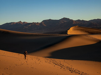
Photographing the Mesquite Flat Sand Dunes at Sunrise.
Once the sun crested the horizon, the dunes exploded with color! Pale beige sand turned into bright orange, and the contrast on the dunes made for incredible images. While we hiked, we interacted with a few other hikers, but for the most part, we had the dunes all to ourselves. If you're going to visit the dunes, I highly recommend hiking way out past the first few ridges where you'll be treated to pristine dunes with little to no traces of human contact. The first few ridges of dunes have seen so much foot traffic that they look dimpled like a golf ball with foot prints everywhere, so it really does pay off to hike out beyond everyone else. With the sun now high above the horizon and the morning glow giving way to bright blue skies, we hiked back to the trailhead, turning back occasionally to soak in the dunes in the distance.

When visiting Death Valley, the forces of erosion are apparent wherever you look. In fact, much of the valley has taken shape through repeated, although rare, flash flooding events. Nowhere, in my opinion, is this more evident than in the Mosaic Canyon. Flash flooding has carved this canyon and strewn large boulders along its path. For the geology fans, this canyon also features interesting layers of Mosaic Canyon Breccia (which gives the canyon its name) and polished marble walls. The hike is about 2-3 miles out-and-back depending on how far you decide to take it, though be prepared for rock scrambling if you do the entire length!

Continuing along our journey, we made our way out of Death Valley and into the neighboring Panamint Valley. This desolate valley on the west side of the park features an immense dry lake bed, or Playa, that stretches for miles in each direction. We pulled over to the side of the road and began walking out on the flat and dried up ground. Other than the occasional car screaming by at 80+ mph, the desert was eerily silent. Not often do you have the chance to look out on an endless horizon with so few distractions. No noise, no wind, no movement, just the endless playa...
Apart from conjuring up semi-existential contemplation, the desert was a pleasant place to spend the evening, and we even caught the sun setting against the Panamint Butte in the distance. For the night, we stayed at the nearby Panamint Springs "Resort," and yes, I put that in quotations because "resort" is a very loosely used term for what constituted our sleeping arrangements that night.
Day 3 - The Alabama Hills

Mobius Arch with Mount Whitney in the distance
After visiting the lowest elevation in the US only a day before, we made our way to the highest elevation in the contiguous states (14,505 ft) at Mount Whitney near Lone Pine, CA. Well, technically we didn't reach that elevation, but the views of the peak were pretty spectacular. Lone Pine is a small town known for many things: Mount Whitney, the Alabama Hills, and being the filming site of hundreds of movies (predominantly Westerns). We wasted no time once we got into town and drove straight up into the hills. With construction occurring on the main road towards the Whitney Portal, we had to take a narrow, winding detour instead. This road would turn out to be one of the most beautiful roads I've ever been able to drive on.

Our detour winding through the Alabama Hills
Dotted with massive boulders and incredible rock formations, the Hills are an adventurer's playground. We hiked the Mobius Arch Loop Trail which offers a unique view of the Sierras framed in the background (see the first photo above). Continuing along the "Movie Road" there are a handful of other hiking trails to explore and overlooks to enjoy. Since the land is owned by the BLM, it's the perfect place to bring your tent or camper van, with ample spaces within the rock formations to set up for the night. The camping sites are dispersed enough that each camper gets to have their own isolated getaway in the hills.
An addition to our afternoon that we hadn't imagined seeing, or better yet hearing out in the wilderness, were waves and waves of fighter jets flying over the Sierras and through the valley. Every 15 minutes or so we would hear the gradually intensifying sound of a jet engine and watch as the planes flew overhead. Some 50-60 years ago, my Grandfather was flying that same route over the Sierras as a Navy pilot. My Dad and I would watch them fly over then talk about the stories he was told when he was young about his Dad making the trip over the mountains. It was an amazing full circle moment for us both.
We were told by a few locals that one's stay in Lone Pine wouldn't be complete without a visit to the Museum of Western Film History. Since 1920, Lone Pine and the Alabama Hills area have been the setting for a long list of western films and TV shows. If westerns are your thing, this museum has it all for you. The museum features a plethora of memorabilia used on the actual sets of many of the movies and shows that were shot in town. Although most of the movies shot in the area predated me and my dad, the area is still used occasionally for a big blockbuster film and numerous car commercials.

Driving up the Whitney Portal
Continuing our day of exploring Lone Pine, we drove up the Whitney Portal Road to push further into the Sierra Mountains. We quickly ascended out of the desert and into a forested and alpine world, something we hadn't experienced on the trip so far. In summer, this road would have been bustling with crowds of hikers preparing to summit Mount Whitney. But during late fall, we were the only ones making our way up the Portal. The peaks, made almost entirely of granite, were incredibly impressive up close. Even as we drove closer to Mount Whitney, the peak continued to look further and further away. Had we visited earlier in the year, we could've taken the 21 mile out-and-back trail to the peak, with over 6,600 ft of elevation gain. But alas, all we could do was marvel at the peak from the valley floor.
Day 4 - Ancient Life in California

Eastern Sierras at the breaking of dawn.
Rising early on our final day of the trip, still 5+ hours from our final destination, we drove back out into the Alabama Hills to catch the sun rising against the Sierra Mountains. We pulled off at a beautiful vista we scouted out the day before, overlooking the hills and the mountains in the distance. The stars were still out and a waning full moon was descending behind the mountains when we first arrived. Over the course of the next hour and a half, we watched and photographed the mountain range as the lighting went from a soft yellow glow to a bright red and direct sunlight. Each few minutes I would click my shutter thinking that this would be the best it would get... And then it would continually get even better!

Sunrise hitting the tops of Lone Pine Peak (Left) and Mount Whitney (Right).
The morning reached it's crescendo when the sun finally rose over the horizon and struck the top of Mount Whitney and Lone Pine Peak. For only a few minutes, we were treated to an incredible display of light before the sun disappeared behind a sheet of clouds, not returning until much later in the morning. Had we shown up any later for the sunrise, we would have totally missed out on the opportunity to capture the light hitting the peaks. The sunrise left us buzzing with so much excitement that we almost forgot how cold we were in the frigid morning temperatures. We finally decided to leave the hills and grabbed some coffee in town to warm up.


Bristle Cone Pine Trees in the White Mountain Wilderness
With only a handful of hours left in our journey, we took a detour and drove north to the White Mountains Wilderness. It was there that we would find the oldest living things on earth, the ancient Bristle Cone Pine trees. The oldest of which, the Methuselah Tree, is estimated to be over 4,600 years old! To reach the trees, we had to drive up to over 10,000 ft of elevation. The trees have managed to thrive in the harshest of conditions—high elevation, dry weather, and challenging soil—and have done so for thousands of years! We hiked among some of the oldest trees, though the location of Methuselah is a tightly kept secret for its own protection. Looking up at the trees, in their gnarled and elderly state, gave me such an appreciation for the life we get to encounter here on Earth and how precious yet resilient it is. It was an epic way to end a trip with so many different superlatives: The lowest elevation in the US, the highest elevation in the lower 48, and the oldest living things on the planet.
Thanks for tuning in to this edition of my Photo Adventure Blog! If you want to check out more images from the trip, check out my new Golden State Gallery. And if you really liked some of the images, be sure to check out my print shop for newly released prints from this trip. Also, be sure to subscribe to stay up to date on all my new photo adventure content!
Comments